A warmer Wednesday across Metro Detroit before severe weather threat arrives Thursday.

By Ashlee Baracy
Published on March 25, 2026.
A 4Warn Weather Alert has been issued for Thursday afternoon and evening due to the threat of severe storms across Southeast Michigan. High temperatures are expected to reach the upper 50s and upper 60s on Thursday, with showers and thunderstorms expected to develop. From I-696/I-96 south, there is a slight (level 2 out of 5) risk for severe weather, while a marginal (level 1) risk is expected from I-690 to around I-69. Hail and tornadoes are the most significant threats, with conditions favorable for large hail up to 2 inch/tennis ball-sized. However, most of the area will be at risk for isolated damaging wind gusts greater than 60 mph. The next chance for rain after Thursday's storms will be Tuesday of the week.
Related Articles

Get ready for another big warm-up before a cold front comes later this week
A cold front is expected to bring hot weather, but potentially dangerous weather, with potential record-breaking temperatures and strong storms forecasted later this week.
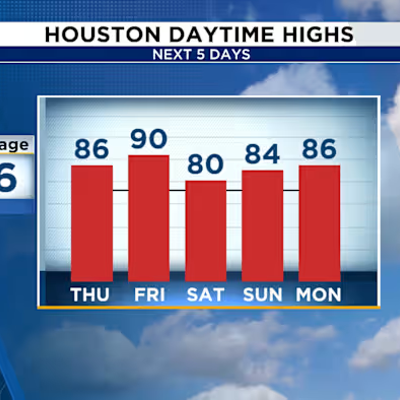
Tracking another warm day in Houston before hitting the 90s mid-week
Despite being above average, temperatures are set to rise again this week, with potential for increased rain and windfall, though conditions remain relatively mild.

Mobile home fire in West Little River damages 3 units; good Samaritan suffers minor burns
A fire in Northwest Miami-Dade caused significant losses to three units, including one to a good Samaritan, leaving him with minor burns.