Thunderstorms, gusty winds this weekend, cooldown on the way
By Noah Price
Published on April 11, 2026.
The weekend will see increasing cloud cover, with chances for scattered showers, thunderstorms, and gusty winds across Utah. The upper-level low off the coast of California will continue to provide a southwesterly flow increasing moisture across the region, leading to the development of scattered showers and thunderstorms across higher terrain and Eastern Utah, with the best chances for thunderstorms along and east of I-15. The biggest threat is the potential for heavy rain, which could lead to flash flooding across burn scars and slot canyons. A slight break from the activity will occur late Sunday evening and into the overnight hours as a cold front approaches. High elevation mountain snow is likely, with snow levels starting at around 7,500′ and above for the weekend before dropping to around 6,500'' by Monday as the cold front passes. Temperatures will remain above average throughout the week, with temperatures expected to drop below average. However, this active weather pattern appears to be favorable in helping to improve worsening drought conditions.
Related Articles
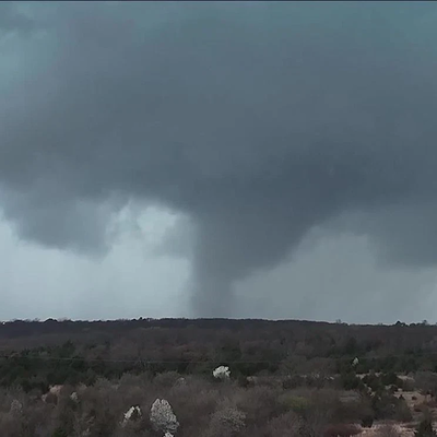
OEM says to stay weather aware ahead of multiple days of storms across Oklahoma
The Oklahoma Department of Emergency Management (OEM) urges people to be aware of multiple days of potential severe weather, particularly during the winter months, with severe weather forecasted.
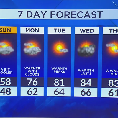
Warm front approaches, record high temps anticipated
A warm front is expected to push up temperatures to near 20-30 degrees in the early hours of Monday, with potential record highs
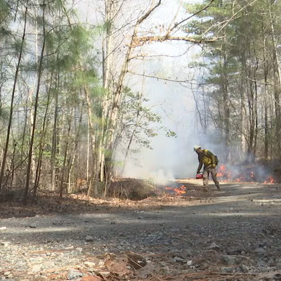
Hurricane Helene debris could impact NC fire risk for decades
The North Carolina Forest Service warns that significant amounts of debris from Hurricane Helene could fuel wildfires in the future.